🗺️ Locating and Defining the Caribbean Region and its Diaspora
- The idea of the Caribbean is abstract and difficult to pin down.
- As a matter of fact, you are unlikely to capture all of the characteristics of the Caribbean if you subscribe to any one definition.
- For example, if you rely solely on geographic definitions you will find that some territories that are considered to be part of the Caribbean do not fit neatly into the geography of the Caribbean.
- Guyana, geographically found in South America, is a great example of this.
- With these notes in mind, it is important to look at several components to comprehensively define the region. These components include:
- geographic
- geological
- historical
- political
- diasporic
Defining the Caribbean Geographically
Geographical definitions of the Caribbean will cover:
- locating the Caribbean on a map
- locating and defining the various subregions and island groups.
- population and geographical size
With that said, here are some of the ways in which you can define the Caribbean geographically:
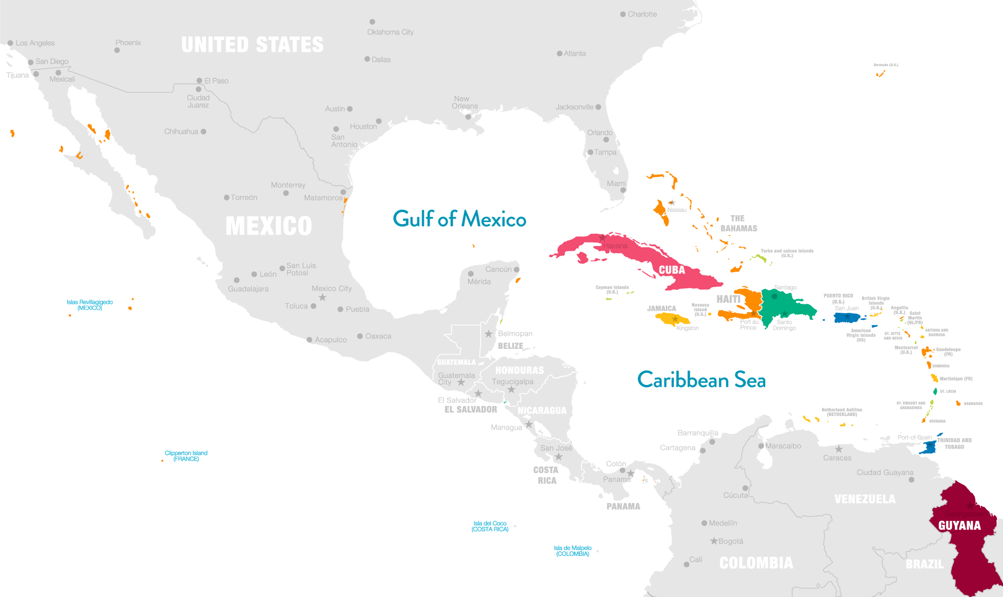
🗺️ Locating the Caribbean on a Map
- the archipelago of islands washed by the Caribbean Sea, and its surrounding areas. It is also referred to as the Caribbean Basin
- The region southeast of North America and the Gulf of Mexico, east of Central America and northwest of South America.
📏Population and Geographic Size
- The Caribbean is approximately 1,063,000 square miles (2,754,000 sq. km) in size.
🏝️The Subregions and Island Groups
The Caribbean is divided into four sub-regions:
- The Lesser Antilles is made up of three island groups: the Windward Islands, the Leeward Islands, and the Leeward Antilles. The Lesser Antilles is the group of islands that stretch from the Virgin Islands to Trinidad.
- The Greater Antilles are the four largest islands – in size – in the Caribbean: Cuba, Hispaniola (Haiti and the Dominican Republic), Jamaica, and Puerto Rico.
- The Mainland Territories of the Caribbean are Belize, Suriname, Guyana, and Cayenne.
- The remaining territories that make up the Caribbean are the Cayman Islands, The Bahamas, and Turks and Caicos Islands.
| SUBREGION | 🏝️ISLAND GROUP | COUNTRIES |
| Lesser Antilles | Windward Islands | 🇱🇨 Saint Lucia 🇧🇧 Barbados 🇩🇲 Dominica 🇬🇩 Grenada 🇻🇨 St. Vincent & the Grenadines 🇹🇹 Trinidad and Tobago |
| Lesser Antilles | Leeward Islands | 🇦🇬 Antigua and Barbuda 🇻🇮US Virgin Islands 🇻🇬British Virgin Islands 🇦🇮 Anguilla St Martin St Barthélemy Saba St Eustatius 🇰🇳 St Kitts and Nevis, 🇲🇸 Montserrat 🇬🇵 Guadeloupe |
| Lesser Antilles | The Leeward Antilles (formerly the Netherland Antilles) | 🇦🇼Aruba 🇧🇶Bonaire 🇨🇼Curaçao |
| Greater Antilles | – | 🇯🇲 Jamaica 🇭🇹 Haiti 🇩🇴Dominican Republic 🇵🇷Puerto-Rico |
| Mainland Territories | – | 🇬🇾Guyana 🇸🇷Suriname 🇬🇫Cayenne 🇧🇿Belize |
Defining the Caribbean Geologically
Geological definitions of the Caribbean will cover:
- plate tectonics
- plate margins/boundaries
With that said, here is how you can define the Caribbean geologically:
Plate Tectonics
- the area defined by the Caribbean Plate.
- The territories of much of the eastern Caribbean, have been formed from the impact of plate tectonics. The area is characterized by the Lesser Antilles archipelago, which developed from tectonic activity along the destructive plate margin at the eastern edge of the Caribbean Plate. The Caribbean Plate interacts with the Nazca and Cocos Plates to the west, the North American Plate to the east and north, and the South American Plate to the south.
Defining the Caribbean Historically
Historical definitions of the Caribbean identify the Caribbean as a group of islands and territories with shared/collective historical experiences. These collective experiences span colonization, slavery, and indentureship.
Colonization
- starting from about the 16th century Caribbean territories were colonized by European powers.
- Primary colonial powers were: Britain, France, Spain, and Holland.
- The presence of colonizers conflicted with the
- slavery:
- indentureship, and the plantation system.